Subject: United States
Period: 1867 (dated)
Publication: Dept. of the Interior
Color: Hand Color
Size:
55 x 28 inches
139.7 x 71.1 cm
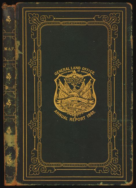
This exceptional example is in original book form with the map mounted on original linen. The presentation binding is green leather with decorative gilt embossing around and the GLO shield at center. Tooling on the spine and the title "Map." Full marbled end papers.
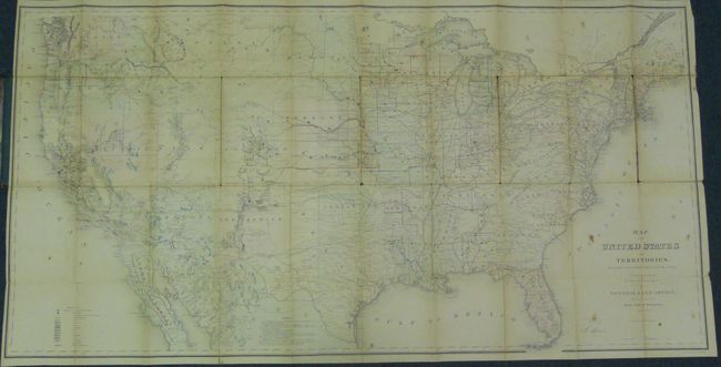
This map, in full original hand color, is one of the more remarkable maps produced by the General Land Office. It shows the extent of the Public Surveys just after the Civil War and includes many items of great interest. Most significant are the gold, silver, copper, and other mineral deposits that are color-coded to mark their location. The sites of army forts and posts provide an excellent view of the undeveloped territories and the western frontier. Details include land grants, townships, subdivisions, railroads, mining districts, etc. Present-day Wyoming is unnamed and shown as part of the Dakota Territory. In the West, survey progress is still limited with much of Southern California complete, but only small areas of New Mexico and Arizona are complete, and with no surveys at all in Utah, Montana and Wyoming. The geological key also locates, via color and icon, deposits of quicksilver, iron, tin, asphalt, coal and oil springs that are shown scattered throughout the country. Constructed from Plats and Official Sources of the General Land Office under the direction of Hon. J.S. Wilson, Commissioner, by Joseph Gorlinski. Signed in the plate by Wilson. The General Land Office (GLO) was created in 1812 to oversee local land offices and in 1849 was incorporated into the Department of Interior.
References:
Condition: B
The map has occasional fold toning, spots and splits, but is well supported by original linen backing. The binding has some shelf wear to edges but image on front and back are very nice.