Subject: Colonial United States and Canada
Period: 1719 (circa)
Publication:
Color: Hand Color
Size:
21.7 x 19.6 inches
55.1 x 49.8 cm
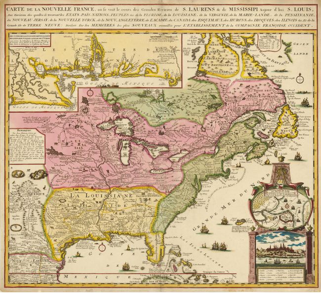
A striking and informative map derived from Nicholas de Fer's important four-sheet map of 1718. It describes the French possessions in North America in the early 18th century. Louisiana and the Mississippi valley are based on Delisle's manuscript map of 1701, while the geography of New England and eastern Canada originates with Franquelin. Inset at top left is a large-scale depiction of the Mississippi Delta and Mobile Bay, based on the expedition of Pierre Le Moyne d'Iberville. A large architectural style cartouche at right encloses both a view and plan of Quebec. The map is filled with minutely engraved wildlife, scenes of Indians hunting, Indian villages and notations. The oceans are embellished with numerous ships, canoes and sea monsters. It is very similar to Chatelain's map of the same title, but this has a more elaborate Quebec inset cartouche and a simpler border for the inset map of the Gulf Coast. De Fer's large map was issued to promote the recently established Compagnie Françoise Occident, which was formed to fund the debt of Louix XIV and offered inducements to encourage settlement in Louisiana. This smaller version is found in atlases published by Ottens and other Dutch composite atlases. There is no engraver or publisher imprint.
References: Kershaw #336; McCorkle #719.5.
Condition: A
Sharp impression and old color with faint soil, mostly in the blank margins. The centerfold and a few edge tears have been professionally repaired.