Subject: North Carolina
Period: 1865 (dated)
Publication: Report of the Chief Engineer, 39th Congress, 1st Session
Color: Black & White
This lot includes the complete extract (pages 1261 - 1276) "Report of Major General B.F. Butler of operations against Fort Fisher, 1864." The report and maps well describe the military operations of the Army of the James at Fort Fisher, North Carolina. The related maps are:
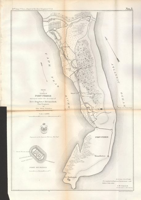
1) Sketch of Vicinity of Fort Fisher Surveyed under Direction of Brvt. Brig. Gen. C.B. Comstock, Chief Engineer, (9.6 x 14.2"). Provides good detail of the peninsula, locating Ft. Buchanan, Mound Battery, Fort Fisher, the headquarters, Wharf, Hospital, the Commissary and Fort Lookout to the north. Also locates the Wreck of the "Powder Vessel" some 830 yards north of Fort Fisher. Toned along folds and a small inset hole near center. (B)
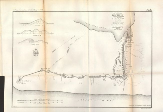
2) Plan and Sections of Fort Fisher, Carried by Assault by the U.S. Forces, Major General A.H. Terry, Commanding, January 15th, 1865, (15.3 x 10.5"). Very close detail of the Fort to show the position of all armament along the fortified walls. Locates cannon ("rifle") locations including the huge Columbia 10" cannons at each end with many smaller (4.5" to 8") cannons positioned between. The map shows Electric Wires leading out from the walls to a Line of Torpedoes protecting the open ground beyond the fort's wall. This is the first time we've seen this weapon mentioned on any map. Further research shows electrically triggered land-based torpedoes were used as early as during the Crimean War, 1854-1856. Toned along folds.
References:
Condition:
See individual descriptions.