Subject: United States - Midwest
Period: 1843 (dated)
Publication: House Doc 52, 28th Congress. 2nd Sess.
Color: Black & White
Size:
30 x 36 inches
76.2 x 91.4 cm
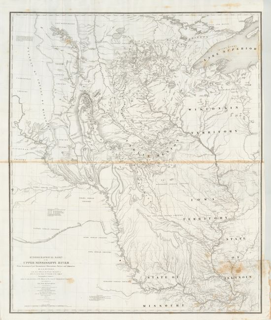
This extremely important map is the first accurate map of this interior region of which the contemporary cartographer Lt. G. K. Warren said was "one of the greatest contributions ever made to American geography." The map covers the region between St. Louis and the international boundary with Canada. The map was compiled by Lt. W. H. Emory (under the direction of Col. J. J. Albert) from the surveys of J. N. Nicollet, who was assisted by Lt. J. C. Fremont; thus, bringing together some of the most important names in the history of American mapping in the 19th century. Nicollet, already a noted French scientist and topographer, was chosen to lead this expedition during 1838 to 1840. The map reflects, for the first time, the use of the barometer to obtain elevations and the use of place names on maps based on a systematic analysis of Indian and French names. It is the first truly scientific topographical survey of the interior of North America. Lithographed by C. B. Graham and printed on two joined sheets. This edition was "Published by Order of the House of Representatives."
References: Schwartz and Ehrenberg plt. 165.
Condition: B+
The majority of the map image is fine with a crisp impression on clean paper. The paper join is toned across the middle and there is an area of toning or staining at lower right corner that is lightly mirrored in upper right corner. Original full margins with binding trim at right side. Folding as issued.