Subject: South-Central United States, Indian Territory
Period: 1844 (published)
Publication: Commerce of the Prairies
Color: Printed Color
Size:
15.4 x 12.5 inches
39.1 x 31.8 cm
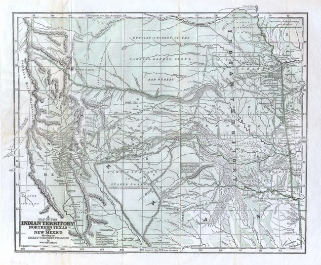
This is a landmark map of the western territories, mapping the area from Missouri, Kansas and Louisiana to the Rocky Mountains. This is the first edition of this map, published just before the more common Morse and Breese atlas map, also dated 1844, but published in 1845. Morse and Breese are named as publisher of this map as well. It shows the northern part of the Republic of Texas reaching along the Rockies and has quite a bit of Indian Territory as well. New Mexico is shown, with Santa Fe as the destination of the route of the Santa Fe Caravans. The map has many tracks of explorers and other routes shown, with topography, towns, villages, smaller villages and ranches, Indian villages, forts, trading posts, ruins, springs, and camps. This would have been a very valuable map for anyone considering traveling across the prairie in the mid 19th century. This the more desirable folding version published in Gregg's publication rather than the unfolded Morse & Breese atlas edition.
Josiah Gregg first went west in the 1830's to look for a cure for his tuberculosis. He recovered his health and traveled across the prairies as a merchant to Santa Fe, Texas and Mexico. He published his account of the region in 1844, which is the source of this map. Wheat calls this map a 'cartographic landmark'. The full title of Gregg's book is Commerce of the Prairies: Or the Journal of a Santa Fe Trader, During Eight Expeditions Across The Great Western Prairies, and a residence of nearly nine years in Northern Mexico. Illustrated with Maps and Engravings.
References: Wheat (TMW) #482; Wagner & Camp #108.1.
Condition: B+
Folding as issued. This map is normally found with toning and fold flaws, this being a nice example that is clean and bright. Invisibly accomplished repairs on verso using tissue close two tears and some weak folds, otherwise a fine example that appears at first glance as flawless.