Subject: Atlases
Period: 1822 (dated)
Publication:
Color: Hand Color
Size:
9.3 x 11.3 inches
23.6 x 28.7 cm
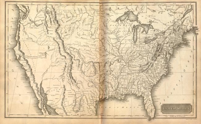
This is the Morses' significant early American atlas, complete with a double-hemisphere map of the world, North America, a double-page map of the United States, Canada, West Indies, South America, Europe, its various nations, Asia, Africa, Hindoostan, and the Pacific Ocean. The map of the United States, engraved by Annin & Smith, is similar to the one engraved by N. & S.S. Jocelyn and published in Morse's Atlas of the United States [1823] and New Universal Atlas of the World [1825], which is cited by Wheat. This earlier map is not mentioned. The map features the Oregon country with the overly-long Multnomah (Willamette) River. There is no northern boundary shown, although it appears that the U.S. extends into present-day British Columbia. In the west, which is mostly labeled Unexplored Country, a dotted line connects a lake in the vicinity of Salt Lake to the Pacific accompanied by a note, "Supposed River between the Buenaventara and the Bay of Francisco which will probably be the communication between the Atlantic and the Pacific." Title, table of contents, 20 maps, partially colored probably by a previous owner (as was customary during the period). Hardbound in original quarter leather and marbled paper boards.
References: cf Wheat [TMW] #355; Phillips (A) #306.
Condition: B
Maps with some minor soil and toning. Boards are scuffed and spine is deteriorating, although binding is still tight.