Subject: Balkans
Period: 1668 (published)
Publication: De Regno Dalmatiae et Croatiae libri sex
Color: Hand Color
Size:
20.6 x 17.4 inches
52.3 x 44.2 cm
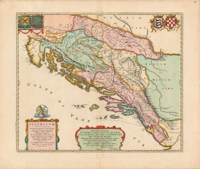
This splendid and rare map of the Dalmatian region of Croatia, Bosnia and Herzegovina marked an important advance in the mapping of this region. It was first issued in 1661 (without a dedication) during a period of relative peace between the House of Hapsburg and the Ottoman Empire, who long contested the region. It was one of six maps in this historical work written by the Croatian historian, Ivan Lucius, head of the Illyrian College in Rome. This educational institution was charged with the preparation of Catholic priests from the Slavic population to counter Protestantism, re-establish a union with Orthodox Christians, and to preach in Ottoman territories. The map took over two years to prepare, incorporated a significant amount of local knowledge, and delineated the Slavic regions that made up contemporary Illyria. This is the second state, which includes the dedication to Péter Zrinyi, Ban of Croatia. This dedication is particularly interesting because at the time, Zrinyi was involved in an anti-Hapsburg conspiracy with several members of the Protestant Hungarian nobility and he was executed shortly after the map's publication. The map includes the arms of Bosnia, Dalmatia, Slavonia and Croatia.
References:
Condition: B+
Fine impression and original color with minor toning along centerfold and a fold separation at bottom just encroaching into the border, closed on verso with archival tape.