Catalog Archive
Auction 132, Lot 42

"An Historical Map of the Roman Empire and the neighboring Barbarous Nations to the year of our Lord Four Hundred when the Empire began to be rent with foreign Invasions", Moll, Herman

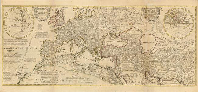
Subject: Ancient World

Period: 1709 (dated)

Publication:

Color: Hand Color

Size:
46 x 19 inches
116.8 x 48.3 cm
Download High Resolution Image
(or just click on image to launch the Zoom viewer)

This large-scale map of the Roman Empire in the year 400 AD includes all of Western Europe and Northern Africa and extends into South-central Asia. Cartouches contain the Latin title at left and the English title at right and maps of the Western Hemisphere and Eastern Hemisphere are inset. The map was derived from Delisle's cartography and is filled with extensive, often fanciful, notations, which are the hallmark of Moll's maps. One indicates that a gold coin stamped with the effigy of Augustus Caesar was found in an American gold mine, confirming the probability that the Roman penetrated as far as the New World. Two sheets joined, as issued.

References:

Condition: B

Original outline color. Some toning on folds with professional repairs on the folds.

Estimate: $500 - $600

Sold for: $375

Closed on 6/2/2010

Archived