Subject: Charleston, South Carolina
Period: 1856 (dated)
Publication:
Color: Black & White
Size:
32 x 30 inches
81.3 x 76.2 cm
The Office of Coast Survey is the oldest U.S. scientific organization, dating from 1807 when Congress directed that a "survey of the coast" be carried out. By 1836, it was called the U.S. Coast Survey and in 1878, the name was changed to the U.S. Coast and Geodetic Survey. Today the Office of Coast Survey is a division of the National Oceanic and Atmospheric Administration NOAA.
The survey teams, composed of civilians as well as Army and Naval officers, charted the nation's waterways and produced a wide array of reports, survey charts, hydrographic studies of tides and currents, astronomical studies and observations, and coastal pilots. These charts are an important record of the changing nature of the nation's coastlines. In additional to coastal charts, the U.S. Coast and Geodetic Survey produced land sketches, Civil War battle maps, and the early aeronautical charts.
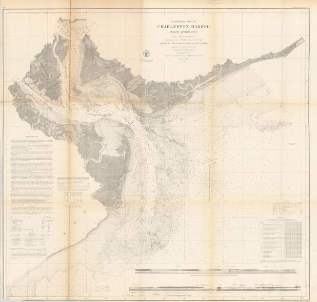
This fine chart of Charleston Harbor extends to show Charlestown and further inland to the confluence of the Cooper and Wando Rivers and part of the Ashley River. It locates the forts of Sumter and Moultrie. It includes soundings, navigational channels, hazards, beacons and lighthouses. For a coastal chart, the inland detail is remarkable with plans of Charleston, Mount Pleasant and Moultrieville, plus land and rivers delineated. St. Michaels and St. Phillips are named in Charleston and the light ship at Rattlesnake Shoals is noted. Two sea views at bottom show the coastline as seen from onboard an approaching vessel.
References: Stephenson (CW) 383.
Condition: B
Nice example on sound paper with noticeable toning along a vertical fold, more so at top panel. Fold separation closed on verso with archival tape. The balance of the map is very good. Folding as issued.