Subject: Florida
Period: 1840 (dated)
Publication: 26th Cong. 2nd Sess. Senate doc. No. 9
Color: Hand Color
Size:
22.5 x 9.3 inches
57.2 x 23.6 cm
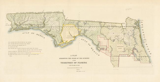
This early, interesting map shows the status of public land surveys in the Eastern and Western Land Districts of the Florida Panhandle. Surveys are complete above the Supposed Indian Boundary Line except those outlined and shaded in red. Survey efforts in south Florida continued to be hampered by the guerilla warfare of the Second Seminole War (1837-1842). The map shows both the Arredondo Grant and Forbes Purchase. The Arredondo Grant was a Spanish Land Grant given to a powerful Spanish merchant and Indian Agent, and the Forbes Purchase resulted from a purchase from the Indians by a group of British traders that had been recognized within the Spanish Land Grant program. After Florida became part of the United States these grants were contested in the courts and finally confirmed by the Supreme Court in 1835.
References:
Condition: A+
Original color. Issued folded, now flattened.