Subject: Midwestern United States - Nebraska, Kansas
Period: 1855 (dated)
Publication: General Atlas
Color: Hand Color
Size:
15.8 x 12.8 inches
40.1 x 32.5 cm
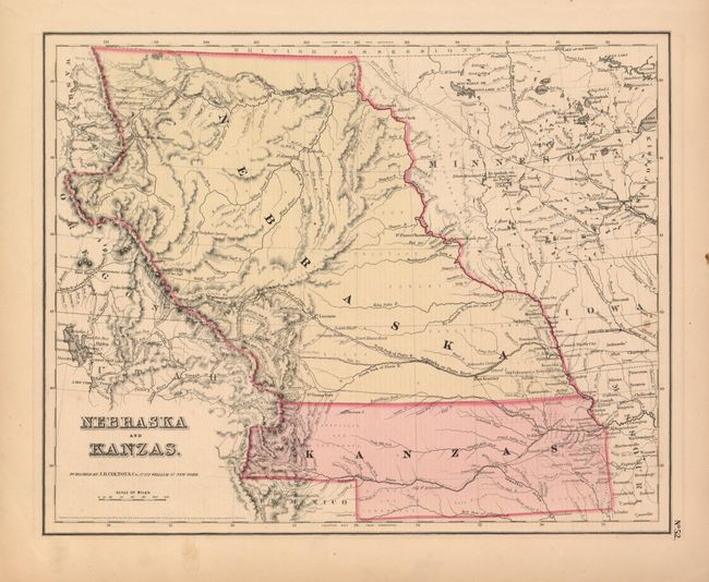
This is the first edition of this important and early map of the transitional territories of Nebraska and Kanzas. In 1854, the United States passed An Act to Organize the Territories of Nebraska and Kansas with this configuration. That act also repealed the Missouri Compromise, allowing slavery in the territories north of the 36° 30´N latitude, provoking violence in the region between pro-slavery and anti-slavery settlers. Nebraska is shown as a massive territory - its northern border to Canada and incorporating the Dakotas west of the Missouri, Wyoming and part of Colorado. Kansas also reaches west to include part of present-day Colorado. Minnesota Territory is shown at its largest extent, with its western border on the Missouri River. The territories are filled with Indian tribes; forts and a few settlements are concentrated along the major rivers. The explored routes for the proposed Pacific railroads are shown. In Wyoming the Rattlesnake Mountains make their first appearance on an atlas map. The General Atlas maps are surrounded by a plain neatline rather than the strapwork border seen on the Atlas of the World issues. The maps are identical.
References: Blevins #96.
Condition: A
Very nice, dark impression with full margins and original color. A little marginal edge toning and a very short edge tear and one chip, all in blank margins.