Subject: Central America, Panama Canal
Period: 1907 (dated)
Publication: Isthmian Canal Commission
Color: Printed Color
Size:
32 x 12 inches
81.3 x 30.5 cm
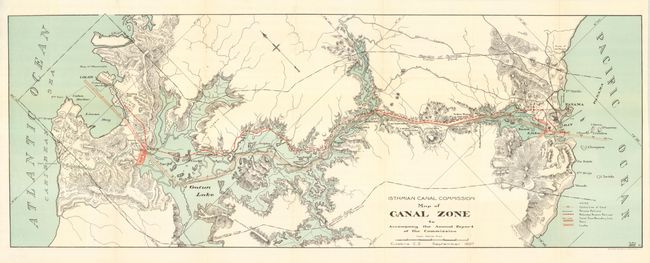
This first edition is a colorful and detailed map that delineates the course of the proposed canal, eventually opened in 1914. The map shows topography, the canal route, and railroads along the Panama Canal Zone from Colon to Panama City. The legend locates the Center Line of Canal, Panama Railroad, Relocated Panama Railroad, Canal Zone Boundary Line, Dams, and Locks through line, color, and iconography. Congress authorized construction of a 'lock' canal in June of 1906. The United States had previously gained use of a ten mile wide "Canal Zone" in a series of negotiations and treaties, as well as purchasing the property of the French Canal Company. Drawn in September, 1907 in Culebra, Canal Zone. Published by The Norris Petters Co., Washington, D.C. A scarce issue in fine condition that may have been issued annually as we have seen a September 1908 edition.
References:
Condition: A+
Fine example, folded as issued.