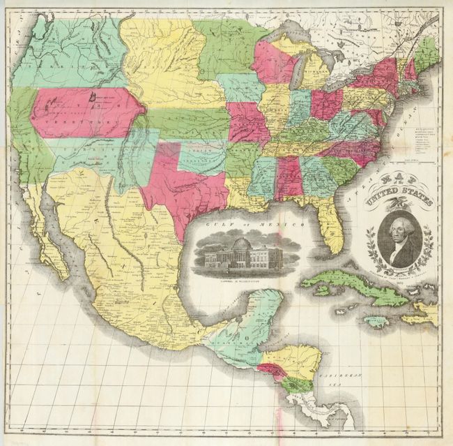
Subject: United States & Mexico, Central America
Period: 1855 (dated)
Publication:
Color: Hand Color
Size:
24.3 x 23.8 inches
61.7 x 60.5 cm
This is a scarce, large format map of the United States with large vignettes of President Washington in an oval boarder, and a nice view of the "Capitol of Washington." The map's projection oddly distorts the western portion of the U.S. The very interesting territorial configurations include an odd pre-Gadsden Purchase border with Mexico that does a bit of wandering, and a large Oregon Territory that occupies the entire Northwest and extends to the Continental Divide. Oregon is bordered to the east by the huge Missouri Territory that extends to an early configuration of Minnesota Territory at the Missouri River. Indian Territory is correctly shown rather than the huge area occupied in earlier editions of this map. Kansas Territory has just formed between Utah and Missouri with no sign of Colorado. Utah and New Mexico territories are at their largest extent. In Utah a Mormon Settlement is located at the southern end of the Great Salt Lake. The map extends to show Central America to below Panama City into Darien and part of the West Indies to Haiti.
References:
Condition: B+
Issued folded, this example is pressed. With full original coloring, printed on thin banknote-style paper. Two folds with tiny, thin splits with archival tape on verso. Close trimmed at binding trim (as issued), and a trace of red color offsetting, otherwise a fine, bright example.