Subject: United States & Mexico, Texas
Period: 1839 (dated)
Publication: Mitchell's School and Family Geography
Color: Hand Color
Size:
16.8 x 10.3 inches
42.7 x 26.2 cm
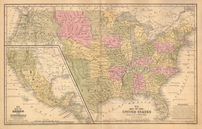
This early map has terrific western territorial borders featuring the Independent Republic of Texas with the long stovepipe border extending well above Pike's Peak to the 42nd parallel. Austin is shown as the republic's capital city. Names Bexar, Victoria, Columbia, Houston, Franklin, Galveston and much more. Notations within Texas include "Herds of Buffaloes and Wild Horses", "Mustang Desert", and "Extensive Prairies." The Great American Desert extends from the panhandle up into the large Indian Territory. The huge Missouri Territory lays between the even larger Oregon Territory and extends to meet the unnamed Sioux lands at the Missouri River. The large Indian Territory fills the region from Texas to Missouri Territory along the North Fork of the Platte River, west to Upper California and east to border with Iowa, Missouri and Arkansas. The large inset "No. 6 Map of Mexico and Guatimala" shows Mexico in control of the entire Southwest up to Oregon Territory and eastward to Texas. The western United states is here named Upper California while the Baja is Old California. An early Mitchell map that was engraved by W. Williams.
References:
Condition: B+
A very nice example in better condition than normally found. Small area of soiling at lower right tip and creased paper at lower centerfold otherwise very good.