Subject: Kansas
Period: 1857 (published)
Publication: HR Doc #103, 35th Congress, 1st Session
Color: Black & White
Size:
48 x 22 inches
121.9 x 55.9 cm
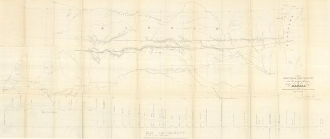
This map describes the important survey that established the southern boundary of Kansas, as surveyed by J.E. Weyss and signed in the plate by J.E. Johnston, Col. 1st. Cavalry. It includes topographic features and good detail. It locates forts, identifies the Santa Fe Trail as the Santa Fe Road, shows the route of Lt. Whipple in 1853, Aubrey's Trail, and names Old Fort Scott, Ft. Union, Raton Pass, Santa Fe, etc. At bottom is a profile of elevations by Dr. Wizlizenus. Map is accompanied with the original three-page report "Southern Boundary Line of Kansas. Letter from the Secretary of War, Transmitting The report of Colonel Johnston's survey of the southern boundary line of Kansas," dated April 15, 1858. A historically important map complete with its short report.
References: Wagner & Camp #301a; Rittenhouse (The Santa Fe Trail) #330.
Condition: A
This large map is in remarkable condition given its size and paper. A few small fold intersection splits and a tear at the binding trim as often seen. Folded as issued and separated from the report.