Subject: Eastern United States
Period: 1820 (dated)
Publication:
Color: Hand Color
Size:
21 x 15.3 inches
53.3 x 38.9 cm
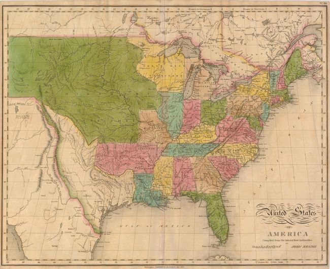
This is a reduced version of Melish's important map engraved by Benjamin Tanner, and published by Mathew Carey & Son for C. V. Lavoisne's atlas. It provides a detailed view of the Missouri River and the headwaters of the Columbia River based on information from Lewis and Clark's expedition. One of the most interesting features of the map is the river system in the West, near the Highest Peak, where the headwaters of several major rivers all originate within a few miles of one another -- Red River of California (Colorado), Multnomah (Willamette), Rio del Norte (Rio Grande), Arkansaw (Arkansas), and the Platte. The new state of Missouri is shown with a straight western border. Michigan Territory includes the eastern part of present-day Wisconsin, which is still a part of the North West Territory. The large Arkansas Territory takes in most of present-day Oklahoma. Texas is separately delineated with its border with Mexico conforming to Melish's map of 1816 - following the Rio Grande up to the Rio Puerco, and then a dotted line that reconnects with the Rio Grande just north of Taos. This is a configuration we have only seen a few times, as most examples of this map show Texas as definitely a part of Mexico.
References: Wheat [TMW] #338.
Condition: B+
Original color with some minor toning and narrow, but adequate margins, as issued.