Subject: Canada & New England
Period: 1846 (dated)
Publication: Mr. Webster's Vindication of the Treaty of Washington in 1842…
Color: Hand Color
Size:
15.5 x 11.8 inches
39.4 x 30 cm
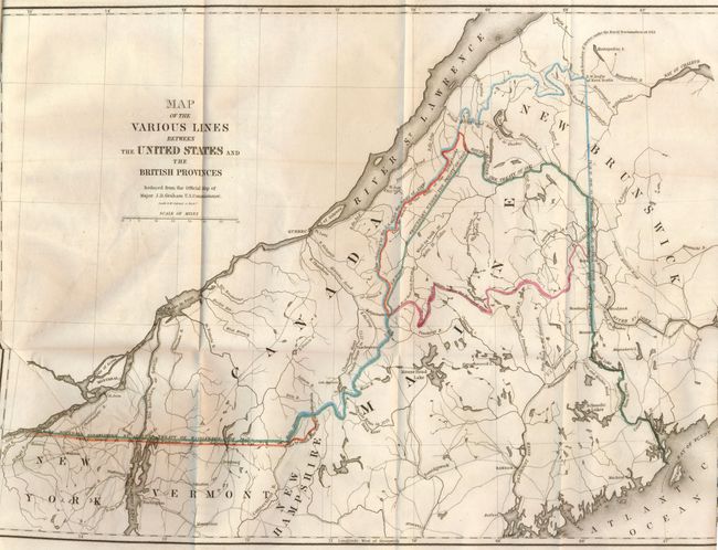
The finely engraved map shows the disputed borders and border treaties between the United States and Canada. The map is centered on Maine and includes parts of the surrounding New Brunswick, New Hampshire, Vermont and New York. Hand coloring identifies Boundary Established by the Treaty of Washington of 1842; Line by award of the King of the Netherlands; and Line claimed by the U.S. under the Treaty of 1783. Also shows the true Meridian Traced by Major Graham.
The map is still bound in the original 88-page report, "Mr. Webster's Vindication of the Treaty of Washington in 1842…" In 1838 Canadian lumberjacks illegally entered the United States to cut timber in the Aroostook region during the winter months. They seized the American land agent dispatched to expel them, thus starting the "Aroostook War." After Maine dispatched 10,000 troops to confront the Canadians, President van Buren sent General Winfield Scott to the "war" zone. Scott arranged an agreement between officials of Maine and New Brunswick that averted any actual fighting. The dispute was settled in 1842 by the Webster-Ashburton Treaty, also known as the Treaty of Washington as it is named on this map. Political opponents later accused Daniel Webster, the lead negotiator, of giving too much land to the British. This report is Webster's answer to these criticisms and is an excellent summary on the negotiations with extensive references to correspondence.
References:
Condition: A
Very nice impression and original hand coloring. Some creasing at binding side.