Subject: Canada & United States
Period: 1786 (dated)
Publication:
Color: Hand Color
Size:
12 x 18.5 inches
30.5 x 47 cm
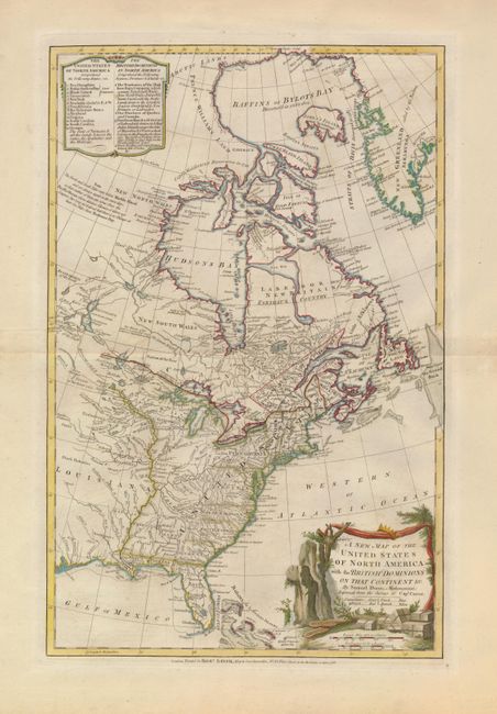
This interesting map was first published in 1774 with the title, A Map of the British Empire in North America. This edition reflects the radical change in Britain's Empire; the British Dominions are now confined to present-day Canada and the fledgling United States takes in the region east of the Mississippi River. A table enclosed in a simple cartouche at top lists the 13 original states, the new state of Vermont, and "all the Lands between the Lakes, The Apalaches [sic] and the Missisipi [sic]," and the three British dominions (Territories of the Hudson Bay Company, Province of Quebec and Canada, and Newfoundland). Spain is shown in possession of Florida and France controls Louisiana. In the United States the boundaries of the states are shown only extending to the Appalachian Mountains with Indian nations occupying the western lands. An interesting notation in Canada declares that there is no passage to the Pacific from Hudson Bay. The decorative landscape cartouche depicts the boxes of tea from the Boston Tea Party of 1773 as well as the paddles the Bostonians used to push any recalcitrant floating boxes back into the sea. This is the 4th state, published by Robert Sayer.
References: McCorkle #786.2; Stevens & Tree #53 (d).
Condition: A
Original color with some minor toning and a couple edge tears in the wide original margins.