Subject: Brazil
Period: 1698 (published)
Publication: Istoria delle Guerre del Regno del Brasile
Color: Hand Color
Size:
19.8 x 14.8 inches
50.3 x 37.6 cm
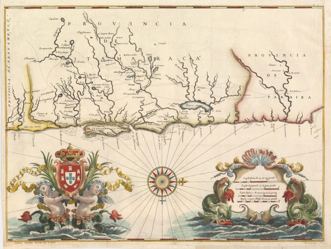
This marvelous map of the Brazilian province of Itamaraca, with part of Paraiba, was one of 23 maps from this rare account of the Dutch-Portuguese colonial war. Written by Joao José de Santa Teresa, and known among bibliophiles as the Santa Teresa, it is considered one of the most sumptuous 17th century works on Brazil. Santa Teresa, a Portuguese Carmelite spent twelve years in the Jesuit missions of South America and then returned to Europe where he became librarian of the college of the Jesuits in Rome. His account was heavily subsidized by Pedro II of Portugal, and some of the period's leading artists and engravers, including Antonio Horacio Andreas, were engaged to work on the project. It was published by Giacomo Giovanni Rossi. The map itself is beautifully drawn and provides an excellent view of the region with rivers and streams carefully delineated, the locations of villages, missions and forts recorded, roads and trails shown, and even navigational hazards shown along the coastline. The elaborate embellishments in the sea flank the fine compass rose and are among the most decorative elements found in cartography. A pair of water sprites hold the Portuguese coat of arms aloft and sea monsters support the distance scale cartouche.
References:
Condition: A
Issued folded, now flattened. The binding trim at upper right has been replaced and the bottom margin has been extended to better accommodate framing.