Subject: Texas
Period: 1920 (circa)
Publication:
Color: Hand Color
Size:
48.8 x 33 inches
124 x 83.8 cm
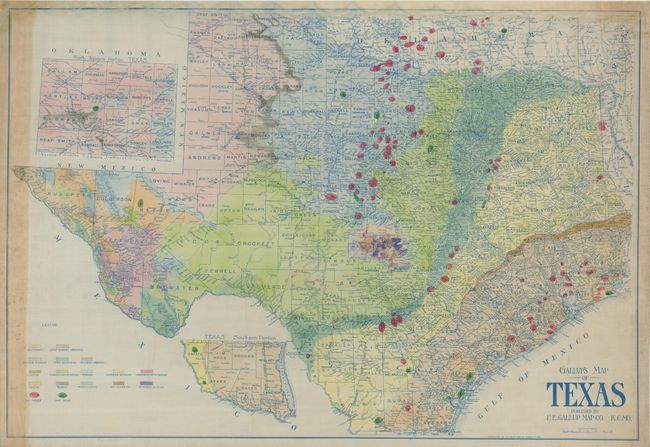
This rare, large edition of Gallup's geological map of Texas focuses on the oil and gas industry. This great map is printed in blue ink on an oiled cloth commonly used for manuscript maps during this period. Very uncommon for this time frame, it uses hand coloring to identify 15 different geological formations as well as all oil fields and gas fields. There are over 80 oil fields delineated, many named, as well as a large number of gas fields. Several oil fields are located in south-central Oklahoma. This map appears to have been a working map as six new fields have been added in manuscript in fine red ink. Each has a number adjacent that appears to be the depth of the formation below. Drawn with amazing detail on a scale of about 16 miles per inch, the map locates towns, villages, railroads, watershed, topography, counties and county seats. Insets cover the panhandle and southernmost Texas on the same scale as the main map. Not shown here is Kennedy County which was formed in 1921, but Hudspeth County formed in 1917 is located, suggesting circa 1918-20. The Amarillo gas field, discovered in 1918 is shown but not the oil fields discovered in 1921. Copyright F.E. Gallup Map Company, Kansas City, MO. This map shares many similarities to Gallup's smaller issue on paper from the same period, which is scarce on its own, but this large issue is quite rare.
References:
Condition: B+
The map is fine with no flaws less the upper and left margins. At the left margin is a strip of discoloration entering the map one inch, and the upper margin is water stained with occasional fading of the blue printed neatline.