Subject: Alaska
Period: 1797 (published)
Publication: Atlas du Voyage de La Perouse
Color: Black & White
Size:
27 x 19.5 inches
68.6 x 49.5 cm
Jean-Francois de Galoup, Comte de La Perouse commanded a French scientific expedition to the Pacific in 1785-88. Recognized as one the foremost naval commanders and navigators in France, he was selected by King Louis XVI to complete Captain James Cook's exploration of the western Pacific. The British Admiralty provided scientific equipment to measure variations in magnetic compass readings and with the latest instruments for determining longitude. La Perouse explored the coasts of the Gulf of Alaska and northwestern North America in search of the fabled Northwest Passage. After leaving America his expedition continued on to Asia where he explored from Macao to Kamchatka and the Solomon Islands in the South Pacific. La Perouse was meticulous in sending copies of his extensive logs, maps and surveying information via other ships as well as overland. La Perouse's last contact was in the spring of 1788 with a British ship in Botany Bay, Australia. The expedition was never heard from again. Considered one of the greatest French voyages, the French Government decided to publish the story of the expedition when it became clear they had been lost. An English edition was published in London.
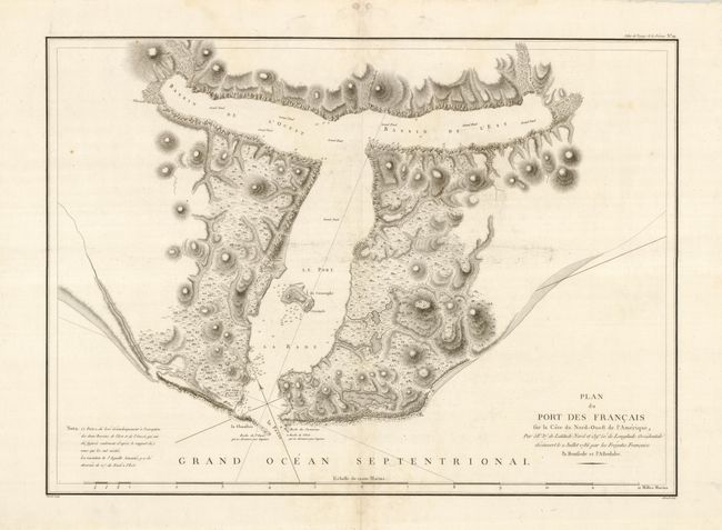
Fine, large chart of Lituya Bay, located within Glacier Bay National Park, along Alaska's southeastern coast. La Perouse discovered the bay in 1786 and named it Port des Francais. He hoped to make it France's major port in the Pacific Northwest and described it as "perhaps the most extraordinary place in the world." He soon discovered what makes the idyllic bay famous today; high (10 feet) tides and strong (14 mph) tidal currents. Twenty-one of La Perouse's men perished in the tidal currents while they were attempting to sound the waters at the narrow entrance. La Perouse built a monument to the lost men on the island in the center of the bay, which he named Cenotaph (meaning empty tomb) Island.
References: Falk #1797-11; Wagner #842.
Condition: B+
There is an extraneous horizontal crease and a couple tiny holes in the blank areas of the map.