Subject: Continents
Period: 1669 (dated)
Publication:
Color: Black & White
Size:
14 x 3 inches
35.6 x 7.6 cm
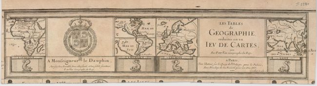
This is the title cartouche, trimmed from the set of 52 playing card maps that were engraved on a single sheet. The engraving includes four tiny maps of the continents of Africa, the Americas, Europe and Asia. The map of the Americas is noteworthy for the island of California, a massive landmass in the north Pacific, and the usual configuration of the huge southern continent. Early playing cards often featured a geographical theme, though relatively few featured actual maps. These were often printed with the entire set on a single sheet from which the individual cards were cut. These maps are extremely rare because their survival rate was very low due to their ephemeral nature, and the separate title cartouche is even more rare.
References: King (2nd ed.) p. 22.
Condition: A
Lightly toned with margins adequate for framing.