Subject: Western Hemisphere
Period: 1635 (published)
Publication: Theatrum Orbis Terrarum
Color: Hand Color
Size:
21.8 x 16 inches
55.4 x 40.6 cm
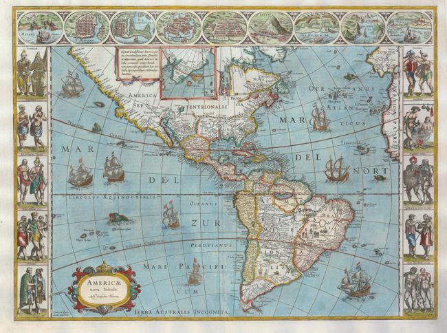
This magnificent carte-a-figures map is a superb example of the fine art of decorative cartography and a seventeenth-century European view of the New World. The coastal outlines generally follow Ortelius and Wytfliet with nomenclature from a variety of explorers and colonists. Panels at sides, each with five portraits of the native inhabitants were taken from John White (Virginia), Hans Staden (Brazil) and other early accounts. Across the top are nine town plans including Havana, St. Domingo, Cartegena, Mexico City, Cusco, Potosi, I. la Mocha in Chile, Rio de Janeiro and Olinda in Brazil. This is one of the few maps of the Americas by this famous Dutch cartographer. The map itself is similar to Blaeu's wall map of 1608 with the additional discoveries of Henry Hudson and Tierra del Fuego with Le Maire Strait. This is the third state of the plate from a German edition with the coastline of Terra Australis Incognita deleted, but the name left behind.
References: Burden #189; Goss (Blaeu) p. 156; Tooley (Amer) p. 297
Condition: A
The centerfold has been lightly reinforced on verso. Some minor bleed through of color on verso and slight uneven color in the oceans.