Subject: East Indies - Indonesia
Period: 1647 (published)
Publication: Dell Arcano del Mare
Color: Hand Color
Size:
14.5 x 18.5 inches
36.8 x 47 cm
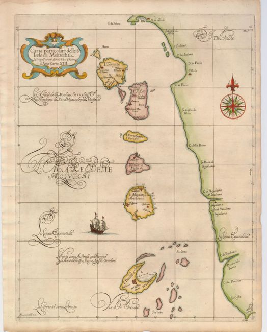
This is the very rare, first edition of one of the most elegant maps of the Maluku Islands; the famous Spice Islands that inspired much of the European Age of Discovery. The tiny islands from Ternate to Bacan are shown in a line off the west coast of Gilolo (Halmahera) and the colonial forts are carefully noted. The distinctive calligraphy (alla cancellaresca), fine cartouche, compass rose and sailing ship are the work of the engraver, Antonio Francesco Lucini.
Robert Dudley was the first Englishman to produce a sea atlas, Dell Arcano del Mare (Secrets of the Sea). He introduced a totally new style for sea charts in the atlas with only lines of latitude and longitude and no rhumb lines. The charts were meticulously compiled from original sources and were both scientific and accurate for the time. This important atlas was the first sea atlas of the whole world; the first to use Mercator's projection throughout; the earliest to show the prevailing winds, currents and magnetic deviation; and the first to expound the advantages of Great Circle Sailing. In an introductory leaf found in one copy in the British Library, the engraver states that he worked on the plates in seclusion for twelve years in an obscure Tuscan village, using no less than 5,000 pounds of copper for the printing plates. It was only issued in two editions and the maps are rarely seen on the market. This map is from the first edition.
References:
Condition: A
Nice impression and lovely later color with slight toning of the paper.