Subject: Southern United States, Mexico & Peru
Period: 1592 (published)
Publication: Theatrum Orbis Terrarum
Color: Hand Color
Size:
18.3 x 13 inches
46.5 x 33 cm
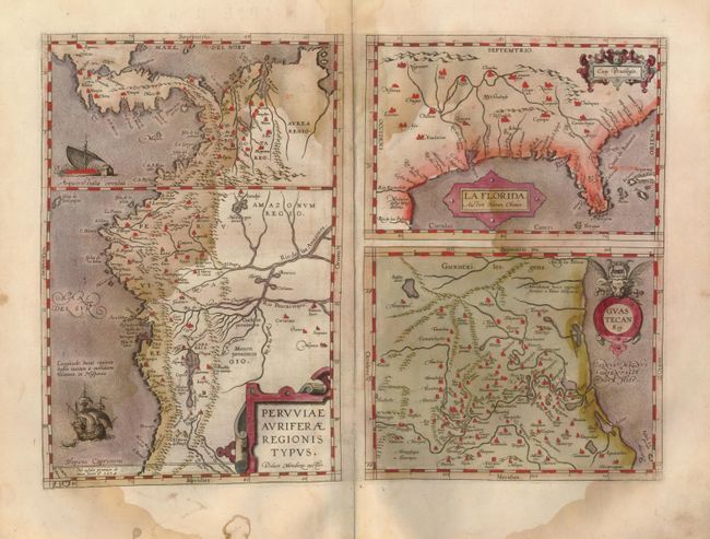
This was one of the few sixteenth century maps based on Spanish sources; in this case drawing from reports of Hernando de Soto's expedition through the region. There are three maps on this sheet. The most important map (La Florida) is the first printed map of the southeastern portion of the United States. This influential map provided the foundation cartography for the region, particularly in the depiction of the river system. The map below (Guastecan Reg) combines with La Florida to extend the coastline of the Gulf of Mexico further south. The third is a map of Peru, where De Soto was the first Spaniard to meet Inca Emperor Atahuallpa. In the north of the map of Peru is Aurea Regio, or Kingdom of Gold, a reference to the fabled El Dorado. All maps contain decorative cartouches, and the map of Peru is embellished with two ships. Latin text on verso.
References: Burden #57; Cumming (SE) #5; Van den Broecke #15.
Condition: C+
Very good original hand coloring, dark, early impression and wide margins on supple, sound paper. A large damp stain engulfs about a third of the map and a small hole in the lower margin at centerfold is well away from map image. Will be a fine example after a simple cleaning by a professional.