Subject: Florida
Period: 1778 (dated)
Publication: Pilote Americain Septentrional…
Color: Black & White
Size:
15.5 x 21 inches
39.4 x 53.3 cm
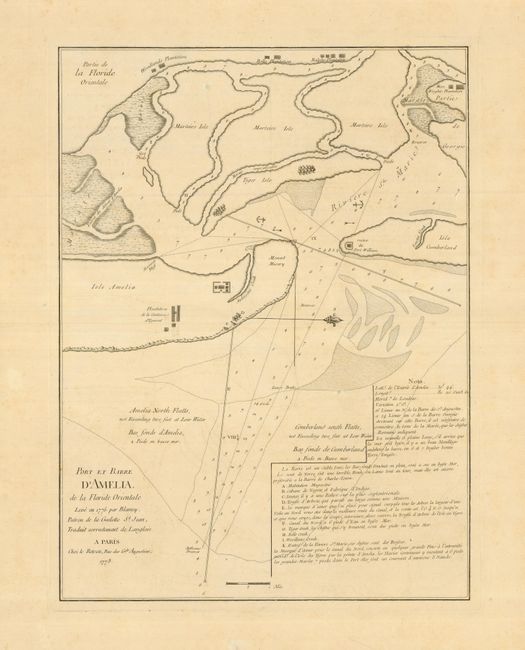
This is the French version of Sayer & Bennett's rare chart of Amelia Harbor, surveyed in 1775 by Jacob Blamey. Amelia Island is located on the boundary between Florida and Georgia. It has a strategic location and is the only territory in the United States to have been under eight different flags during its intriguing history. The anchorages within the deep-water harbor were used for all kinds of sailing vessels including smugglers, pirates, and slave ships. During the American Revolution, the island became home for English Loyalists fleeing the colonies. This map charts the waterways surrounding portions of Amelia Island, Cumberland Island, Martin's (Marteirs) Island and small Tiger's Island, showing anchorages, soundings and hazards. The ruins of Fort William are noted at the tip of Cumberland Island. This fort was built by the British Gen. James Oglethorpe, founder of the colony of Georgia, who successfully repelled Spanish troops from Georgia in 1742. A number of other landmarks and buildings are named, including the plantation of the Countess Dowager of Egmont on Amelia Island, with the reference key below noting the Cabane de Negres, et Fabrique d'Indigo of the plantation. The French version is as rare as the English version, and we find only one dealer catalog record in the past twenty-five years.
References:
Condition: A
Faintly toned with very wide original margins.