Subject: District of Columbia
Period: 1884 (dated)
Publication:
Color:
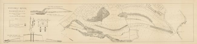
1) 36.8 x 7.5 ", b/w, 48th Congress 2nd Session. This map details the progress of work to improve and stabilize the river bed in front of the capital, current to June 30, 1884. On this land will sit today's Lincoln Memorial, Constitution Mall, Jefferson Memorial, the Vietnam Veterans Memorial and more. Also shows the planned reclamation which becomes the East Potomac Park. The map details the river and shore from above Analostan Island (Theodore Roosevelt Island), Alexander's Island, around Giesboro Point to the National War College near South V Street. Signed in the plate by the Supt. Engs. Folding as issued, fine less a smudge near Giesboro Point (A).
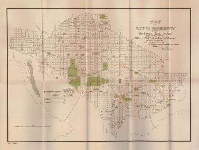
2) 19 x 13.8", printed color, 48th Congress 2nd Session. This thematic map was one in a series by the Engineer Department of D.C. by Col. A.F. Rockwell, in charge of Public Buildings and Grounds. Green overprinting locates important buildings. Table claims 246 "reservations" and each is identified by number on the map with red overprinting. The table also lists Statues (10), Fountains (21), Drinking Fountains (23), and 410 gas [street] lamps. Signed in the plate by the Surveyor Dist. Of Col. With a little light offsetting from green color (B+).
References:
Condition: A