Catalog Archive
Auction 128, Lot 284

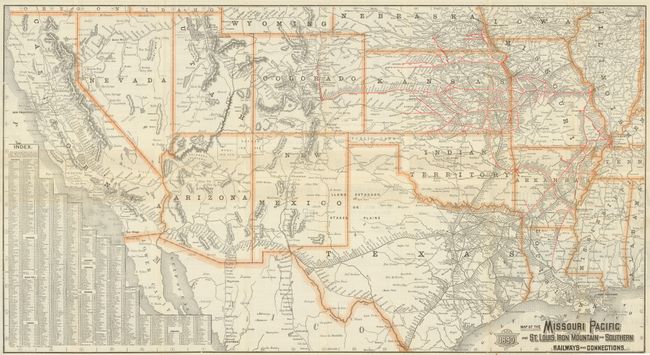
"Map of the Missouri Pacific Ry, Missouri, Kansas and Texas Ry. St Louis, Iron Mountain and So. Ry. International and Gt. Northern R.R. Central Branch U.P.R.R. St. Louis, Ft. Scott and Wichita R.R. Little Rock, Miss. River and Texas Ry. And Connections", Rand McNally & Co.

Subject: Western United States

Period: 1890 (dated)

Publication:

Color: Printed Color

Size:
30.5 x 16.5 inches
77.5 x 41.9 cm
Download High Resolution Image
(or just click on image to launch the Zoom viewer)

This is a folding map and timetable for the Missouri Pacific route, which used the railroads of the Missouri Pacific; Texas & Kansas; Union Pacific; Southern Pacific; Burlington & Missouri; Atchison, Topeka & Santa Fe, and others to build their network. The major routes originate in St. Louis and travel westward though Missouri and to the south into Indian Territory and Texas. The map focuses on the southwest only, extending east to St. Louis and north to include all of California, Utah, Colorado, etc. Texas is shown south to include Laredo and Corpus Christi. Shows, in smaller line, all railroads in the area with the lines of the Missouri Pacific delineated in red overprinting. This great piece of railroad ephemera has an extensive timetable opposite the map. The timetable side is printed in yellow and black. Self-folds into brochure (4" x 8.8") with fully colored cover and graphics.

References:

Condition: A

Very nice example. No internal flaws but covers with a little soiling and one side with agent's stamp in lower portion.

Estimate: $160 - $200

Sold for: $80

Closed on 5/20/2009

Archived