Subject: Southcentral United States
Period: 1866 (dated)
Publication:
Color: Printed Color
Size:
38 x 25 inches
96.5 x 63.5 cm
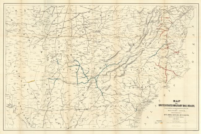
Interesting map produced the year following the close of the Civil War showing the military railroads under the command of Union General McCallum. It provides a clear picture of the railroads involved in the theater of operations during the Civil War. The map is filled with named railroads and stations. The legend uses hand coloring to delineate the various rail gauges throughout the map including 5 ft., 4 ft. 8 1/2 in., and 5 ft. 6 in. gauges. The map is centered on Tennessee and extends northward to show much of Pennsylvania, Ohio, Indiana, and Illinois. To the west is Missouri, with parts of Arkansas and Louisiana, but not to the Gulf Coast. It is filled with place names including some errors like Marks Corner for Moncks Corner, South Carolina. Good detail along the Atlantic coast. Large enough to easily track military operations and troop movements. This edition is uncommon as it is uncolored except for the three gauges of rails which are colored to match the legend, a state we have not previously encountered.
References:
Condition: A+
Folding as issued. Remarkable condition: clean and bright with full margins. This flawless map is by far the best example we've seen.