Subject: Colonial Mid-Atlantic, Virginia
Period: 1627 (published)
Publication: Grand Voyages, Part XIII
Color: Hand Color
Size:
14 x 11 inches
35.6 x 27.9 cm
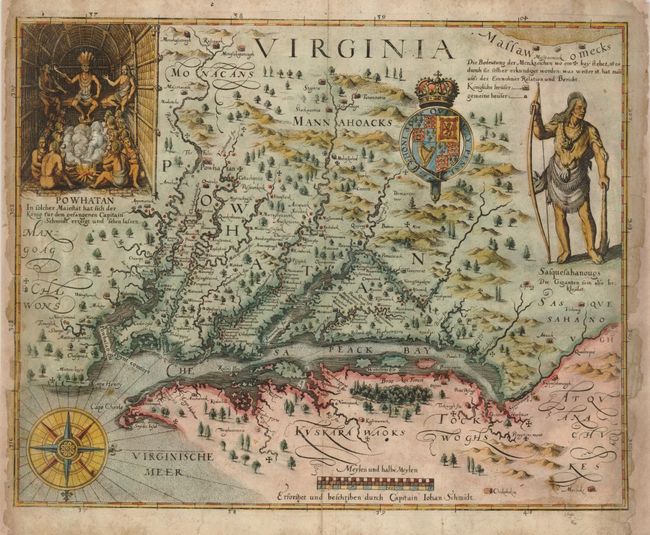
John Smith's map was the most important map of Virginia and Chesapeake Bay of the 17th century. It was the prototype map of the region and was instrumental in creating interest in the new Virginia colony. The map depicts a number of explorations and observations made by Smith and the Jamestown settlers, with small crosses marking the range of those explorations. The information on the locations of the Indian tribes and villages is very extensive; in fact it is still in use by archaeologists today. The decorations are based on John White's drawings made during the first attempt to form a colony in Virginia, as published in the first part of Theodore de Bry's Grand Voyages. This third derivative of Smith's map accompanied the 13th part of the Grand Voyages, which was published posthumously by his son-in-law, Mathaus Merian. This map normally sells in the $5,500-6,500 range, and the estimate reflects the condition.
References: Burden #219; Tooley (Amer) p. 163-4 #3, plt 71; Garratt (TMC-9) p. 9, #G39.
Condition: C+
The map has damaged side margins, which have been extended and the map is backed with tissue. The loss in the margins affects some of the latitude markings outside the neatline, which are inked in facsimile. The extended paper is a lighter color but that would be minimized when the map is framed.