Subject: Eastern United States
Period: 1812 (circa)
Publication: A General Atlas
Color: Hand Color
Size:
11 x 9.3 inches
27.9 x 23.6 cm
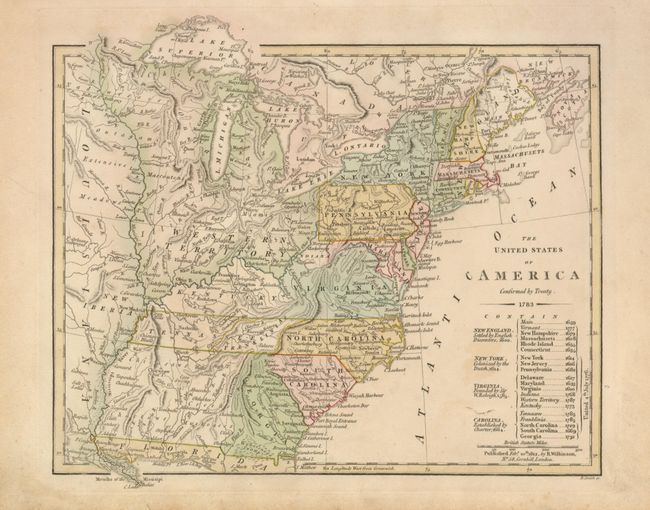
This small map of the young United States includes several important historical regions. One of the most unique and scarce features on early maps of the U.S. is the appearance of Franklinia. In 1785 settlers in present-day western North Carolina and eastern Tennessee organized a state government to be named in honor of Benjamin Franklin. Congress turned down their appeal but the fledgling state maintained a legislature and governor until 1788. This ephemeral state appeared on only a small number of maps into the early part of the 19th century. Another interesting feature is the region labeled Indiana that takes up what is now West Virginia. This land was a major contention between the private Indiana Land Company and the State of Virginia in the latter part of the 18th century. The argument over ownership of the property resulted in the Eleventh Amendment to the U.S. Constitution and the Indiana Land Company lost its claim to the land. Another uncommon regional name is New Iberia, the original Spanish settlement in the region of New Madrid, Missouri. The large Western Territory takes up present-day Michigan, Wisconsin, Illinois, Indiana and Ohio. A table below the title lists twenty states, territories, and governments (including Franklinia) with their founding dates. Published by Wilkinson on February 10, 1812 and engraved by B. Smith.
References: Baynton-Williams (TMC-72) p.12, #15.
Condition: B+
Very nice example with fine impression and original color on thick paper with full margins. Some soiling in margins and a small area of light foxing at lower right of map.