Subject: United States
Period: 1949 (dated)
Publication:
Color: Printed Color
Size:
29.8 x 20 inches
75.7 x 50.8 cm
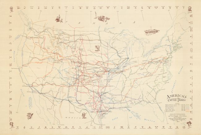
This thematic map of the United States shows historical cattle trails from the Spanish period thought 1895. Legend uses seven different colored lines to indicate Spanish and Mexican Colonial Trails 1540-1846; American Colonial Trails 1620-1776; Pre-Civil War Trails 1776-1861; Civil War Trails 1861-1865; Trails from Texas 1865-1895; Trails from Oregon 1865-1895; and Overland Trails. The colorful confusion of trails crisscross the county, each bearing its name. To mention a few trails: Old Shawnee, Eastern, Goodnight, Dodge City, Smoky Hill, Lander, Pony Express, Chisholm, Jim Stimson, Potter and Bacon, and more. Five vignettes skirt the map including a longhorn. The surrounding border is composed of more than 80 famous cattle brands including Pete Coffin, Flying X, Ten in Texas, and the Broken Heart. At each corner of the border is a vignette of a famous cowboy or trail-blazer; Colonel Wheeler, Charles Goodnight, Francisco Coronado, and Jesse Chisholm. The map was created by Hugh T. Glen, Cartographer and C.O. Froid, Illustrator. Published by the Western Range Cattle Industry Study and the American Pioneer Trails Association, Denver, Colorado. Blank verso. A very scarce map for which we find only two examples, both in museums.
References:
Condition: A+
Clean paper with bright impression and color, and original margins.