Subject: North America
Period: 1704 (circa)
Publication:
Color: Hand Color
Size:
19.3 x 14.5 inches
49 x 36.8 cm
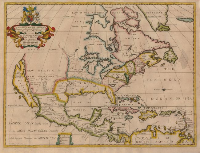
This handsome map features the island of California, which is labeled New Albion, discovered by Sir Francis Drake anno 1577. The general outline of the continent follows Father Louis Hennepin's cartography, and the discoveries in the Mississippi valley are attributed to him. However, the map makes use of fresh sources, especially in the region under English control. Several English settlements are located along the eastern seaboard. A New French Settlement near the mouth of the Mississippi relates to d'Iberville's colony at Biloxi that was founded in 1699. The most notable alteration in the interior is the Ohio River, which is here named the Hotico R. It is shown flowing through the Apalachin M., which inexplicably run east-west in an arc that encloses the Spanish possessions of Florida. The Northwest consists of Parts as yet unknown, the Great Lakes are rather distorted, and a large mythical lake still appears in Carolina. The map is dedicated to His Highness William Duke of Gloucester, with his coat of arms in the title cartouche. It was drawn and engraved by Michael Burghers, the official engraver of the University of Oxford. This is the third state of the plate with additional names added to the Great Lakes.
References: Burden #758; McLaughlin #142; Tooley (Amer) p. 128, #69, plt. #53.
Condition: A
Professional repair of a paper cut to the right of the centerfold, now only noticeable from verso.