Subject: Southwestern United States
Period: 1861 (circa)
Publication: Illustrated Family Atlas
Color: Hand Color
Size:
24.5 x 17 inches
62.2 x 43.2 cm
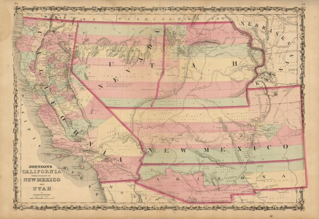
A very nice example of this early map from Johnson's Southwest series. The Confederate Territory of Arizona appears in the southern third of New Mexico Territory. Between August 1861 and July 1862, the Confederate General Baylor appointed himself the territorial governor and claimed all of New Mexico Territory south of the 34th Parallel for the Confederacy. The map names the "Gadsden Ten Million Purchase of Mexico" line between the U.S. and Mexico. Nevada Territory makes an early appearance; its boundary with Utah begins near the Great Salt Lake but wanders south-southwest from Lake Sevier. Hastily added to this plate, 'Nevada' is crudely fitted in an arc between the U and T of Utah. Filled with historical notations, one note near Quartzite, Arizona refers to the area as being "fertile and abundantly timbered and well watered," which it most certainly is not. The Emigrant Road, the Hastings Road, and the routes of numerous explorers and military expeditions are detailed. The Gold Region of present-day Colorado's South Park is prominently shown in what was then Kansas. A superb map of the Southwest.
References: Wheat [TMW] #1027.
Condition: B+
Very nice impression with original color and full margins. Paper missing (3" x 1") in blank upper left margin with paper laid in back, and the faintest hint of offsetting visible in blank area near title. The map shows very well.