Subject: Civil War - Western United States
Period: 1894 (published)
Publication: Atlas to Accompany the Official Records of the Union and Confederate Armies
Color: Printed Color
Size:
27.3 x 16.3 inches
69.3 x 41.4 cm
This lot consists of Plates XCVIII, CXIX and CXX from "The Atlas to Accompany the Official Records of the Union and Confederate Armies 1861-1865."
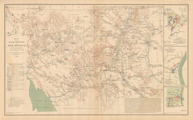
Map of the Military Department of New Mexico... is a fine map of the region of present-day New Mexico and Arizona with great detail throughout. Topography and hydrology are well shown as are army posts, villages and towns, military and explorers' routes, springs, passes, etc. A long legend presents an excellent reference to the map's details. Three unrelated Civil War battlefield plans are inset at right. The map is dated 1864. The map is fine less a light band of offsetting at far lower left. (A)
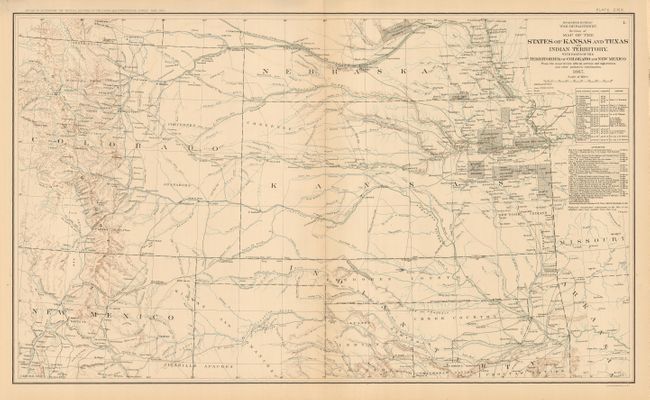
Map of the States of Kansas and Texas and Indian Territory... is an excellent map of the region showing considerable detail. Topography and hydrology are nicely developed. Two tables provide lists of Stations and Authorities with many army posts and exploration routes traced on the map. Numerous Indian Reservations are delineated in Kansas and the plains between the settled regions of Kansas and Denver are shown to be the territory of the Cheyennes and Arapahoes. The map provides an excellent view of the various emigrant roads in the region. Map is dated 1867. The map is fine. (A+)
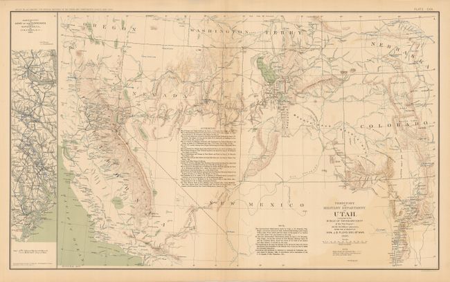
Territory and Military Department of Utah, dated 1860, shows all of Nevada, Utah and most of Colorado in fine detail with mountains portrayed via hachure. It also covers part of California from about Long Beach (San Pedro) north to Oregon. The numerous forts are depicted with blue overprinting and include St. Vrains, Wingate, Camp Collins, Bonneville, Uintah, Ruby, Tejon, Reading, Bidwell, and the camps of McDermot and Summit Lake. Features include topography, watershed, wagon roads and trails, towns and settlements, springs, forts, military routes and campaigns and proposed railroads. Table lists at least 17 sources for this map including the maps of Fremont, Stansbury, Gunnison, Beckwith, Parke, the journal of F. Francisco Silvestre Velez Escalante and several more. Small vertical map at extreme left is titled March Routes of Army of Tennessee from Savannah, Ga., to Columbia, S.C., 1865. The map is fine less a light band of offsetting in lower right quadrant. (A)
References:
Condition:
See individual descriptions.