Subject: Western United States
Period: 1859 (dated)
Publication: New Universal Atlas
Color: Hand Color
Size:
13 x 16.3 inches
33 x 41.4 cm
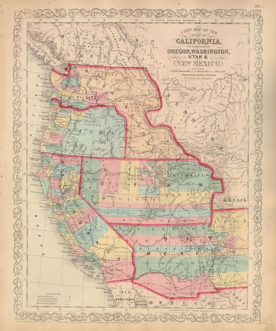
The uncommon Desilver issue of this fine map of California with large western territories from an important series of maps originating with Samuel Augustus Mitchell. The map is filled with early county configurations, the exploration routes of Lewis and Clark, Fremont, Kearney, and Cooke, and the Spanish and Oregon Trails. Of importance is the delineation of the newly discovered gold fields in western Kansas (Colorado) with Gold Region printed along the Front Range from the South Platte River to the Arkansas River. In Washington Territory county development is mostly confined west of the Cascades. Oregon state has just formed, leaving its eastern half to Washington Territory, which is now shaped as an upside down "L", touching Utah in the south and with its eastern boundary defined by the Continental Divide. Utah Territory extends to Middle Park and Long's Peak in present-day Colorado with its eastern border against Nebraska and Kansas. The three vertical counties of Carson, Humboldt and St. Marys form the beginnings of what will become Nevada. There is no sight of the future Territory of Arizona, but the region obtained in the Gadsden Purchase is labeled as "Uninhabited Region." Desilver's unique scroll border, with his imprint at No. 714 Chestnut Street, Philadelphia.
References: Wheat (TMW) #890.
Condition: A
Fine impression and original color on a sheet with lovely ivory age toning and full margins. A little marginal toning, otherwise fine.