Subject: Eastern United States
Period: 1824 (dated)
Publication:
Color: Hand Color
Size:
25 x 21 inches
63.5 x 53.3 cm
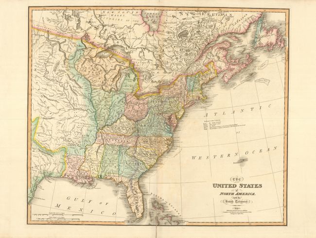
This impressive large map shows the eastern part of the United States to just past the 100th meridian. The huge Missouri Territory incorporates the old Spanish districts of Cape Girardeau, Lawrence, and Arkansas along the Mississippi River, and the French Devallieres Grant (Don Joseph Vallier) just north of the White River. The former Western Territory (still labeled) is now organized into Michigan, Ohio, Indiana, Illinois and Northwest Territory. The map provides excellent detail of Indian tribes, towns, settlements, roads, land grants, etc. There are several interesting notations concerning treaties including the treaty with Britain establishing the northern boundary in 1818, the treaty with Spain establishing the boundary with Texas in 1819, and various treaties with the Indians. Other notations locate Indian hunting grounds, trading places, and the place where the Tribes meet in Friendship to collect Stone for Pipes. Several bounty land grants are shown including Colonel Simmes Donation Lands from the Commonwealth of Virginia, New Jersey, Wabash, and Ohio Companies, Army Lands, Lands Reserved for Virginia Troops and North Carolina Troops in western Kentucky and Tennessee, and Carver's Grant in Northwest Territory. The still disputed border between Maine and Canada is presented in the extreme British conception. The map also features The Twenty Leagues Line located off of the east coast that marked the exclusive maritime jurisdiction of the United States. This map was originated by William Faden in 1777 under the title "The British Colonies in North America." It went through a long series of revisions, each incorporating milestone developments in U.S. history. According to Tooley this is the ninth issue, published by James Wyld, successor to Faden.
References: Tooley (Amer) p. 101, #80-i.
Condition: B+
Nice impression with lovely original color. There is a repair on the fold that affects about 3" of the map at bottom.