Subject: Asia
Period: 1717 (dated)
Publication: Introduction a la geographie…
Color: Hand Color
Size:
12.5 x 9 inches
31.8 x 22.9 cm
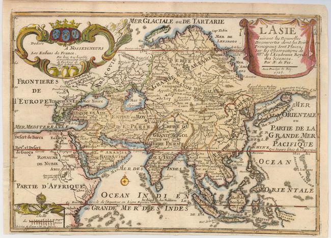
This is an interesting and very unusual map of the Asian continent. The map is based primarily on Dutch sources, particularly the outlines of Siberia and the East Indies. However, the most striking feature, which is original to De Fer, is a continuous land bridge extending from northern Korea and eastern Siberia across to America. A note acknowledges Portuguese sources for this new portrayal of the region. Hokkaido (Ieso) appears as a small circular island north of Japan. The northern coastline of Asia is based on Witsen's explorations including Cap Tabin and Cap Glace. The interior is filled with details, including what appears to be a road from Moscow to Peking, and the Great Wall of China. The Caspian Sea is presented in an unusual shape. The coastline of a portion of New Guinea is incorrectly named as Nouvelle Zeelande. Graced with three beautifully designed cartouches.
References: Yeo #82.
Condition: B+
Issued folding, now flattened. A 3/4" binding tear in the lower left border has been professionally repaired and the binding trim has been replaced.