Subject: Oklahoma
Period: 1879 (dated)
Publication: Cram's Standard American Atlas of the United States
Color: Hand Color
Size:
20 x 14.7 inches
50.8 x 37.3 cm
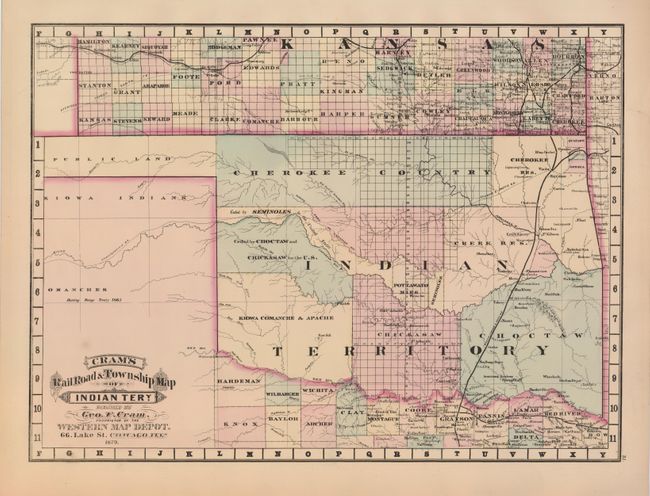
Rare map from the first edition of Cram's most celebrated atlas. This map details the Indian countries and ceded lands including Cherokee, Seminole, Choctaw and Chicksaw, Kiowa, Comanche, Apache, Creek and the Pottawatomies. The railway system crosses the eastern portion through Vinita, Gibson Station, Museogee, and New Buggy Depot, then crossing into Texas at Red River. The panhandle is Public Lands and parts of Texas and Kansas are shown in detail and full hand coloring. The map carries the date of 1879 with a copyright date of 1878. The imprint is Cram's Western Map Depot, 66 Lake St. Chicago, Ills. There was a close relationship between the Cram and Watson firms, who also published from this address. This Lake Street address was the home to Cram's publishing company between 1873 and 1879, thereafter moving to Wabash Avenue. A significant and rarely seen map that should be part of any Oklahoma collection.
References: Chicago Map Makers: "George F. Cram and the American Perception of Space" Gerald A. Danzer
Condition: A+
Bright original hand coloring and strong impression. On a full sheet with wide margins. One small and light spot above title, still fine.