Subject: Southwestern United States
Period: 1892 (circa)
Publication: Atlas to Accompany the Official Records of the Union and Confederate Armies
Color: Printed Color
Size:
27.5 x 16.5 inches
69.9 x 41.9 cm
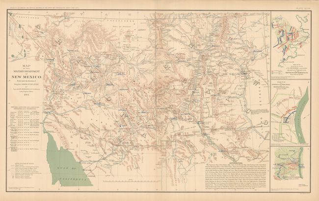
This is Plate XCVIII. The map actually shows all of the territories of New Mexico and the newly formed Arizona which together comprise the Military Department of New Mexico. Beautifully engraved and well colored, this map is more handsome than most from this atlas. It is filled with information on forts, Agencies, wagon roads, exploration routes, railroads, and much more. The explanation of signs lists wagon roads, trails, exploring party routes, streams, arroyos, military posts (occupied and abandoned), and more. The topography is shown via hachure and the waterways are in blue. Prescott is the territorial capital, Forts Whipple, McDowell, McRae, Goodwin, and more are located. Extensive list of Authorities and Astronomical Locations details the work of prominent surveyors. In thin panel at right are battle plans for the Battle of Chickamauga; the Skirmish at Dardenelle, Ark; and the Battle-field of Shiloh, Tenn. Dated 1864 but published 1892.
References:
Condition: A
Map image is fine, with just a little edge toning or staining restricted to edges. One short tear in lower margin, closed on verso. Beautifully colored and printed.