Subject: Reference Books
Period: 1974-99
Publication:
Color:
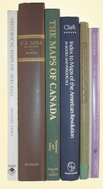
1) Index to Maps of the American Revolution, by David Sanders Clark, Westport CT, 1974. Index to maps illustrating the Revolutionary War and other events of the period 1763-1789, 301pp, (6.5 x 9.5"). Hardbound in blue cloth. Minimal wear, almost new condition.
2) A Bibliography of Printed Battle Plans of the American Revolution 1775-1795 by Kenneth Nebenzahl, Chicago, 1975. A complete list and description of the battle plans of the American War of Independence that were printed between 1775 and 1795. An essential reference for historical research or for a collection of Revolutionary War maps. (6 x 9"), hardbound in burgundy cloth with white title on spine, and an illustrated dust jacket.
3) U. S. Iana, by Wright Howes, New York, 1988. Subtitled, "A Selective Bibliography in Which Are Described 11,620 Uncommon and Significant Books Relating to the Continental Portion of the United States." Second edition, 7th printing. 8vo, hardbound in brown cloth.
4) A Catalogue of Early Globes, by Ena L. Yonge, New York, 1968. A rare index of globes and other associated materials made prior to 1850. (6 x 9.3") Hardbound in green cloth with gilt titles on front and spine, with original onion skin dust jacket. Near fine condition with some chipping to the delicate glassine jacket.
5) The Maps of Canada by N.L. Nicholson and L.M. Sebert, 1981. This is a guide to official Canadian maps, charts, atlases and gazetteers. 251 pp., 45 Figures, 29 tables and maps. (7.6 x 10") First edition. 8vo. Hardbound in green cloth with gilt titling to front cover and spine. Like new condition with some light soiling on cover.
6) Historical Maps of Ireland, by Michael Swift, London, 1999. This book uses cartography to present Ireland's long and sometimes turbulent history, and spans three centuries. (11.3 x 10") 4to. Hardbound in printed paper covers with identical dust jacket and plastic protector. Near new condition with no visible wear.
References:
Condition: A
All books are very good, most are like new.