Subject: Boston, Massachusetts
Period: 1778 (published)
Publication: An Impartial History of the War in America
Color: Black & White
Size:
5.3 x 11.5 inches
13.5 x 29.2 cm
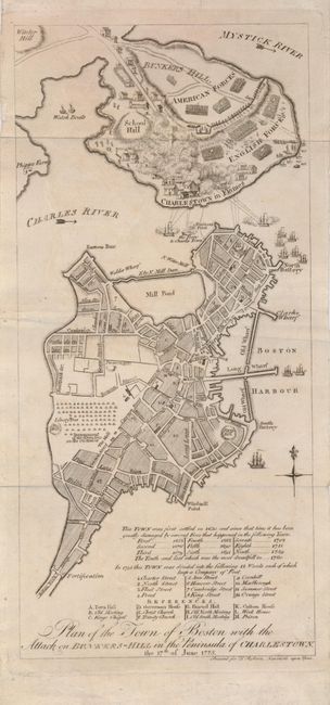
This scarce plan of Boston was derived from an inset in Sayer and Bennett's landmark Revolutionary War map, The Seat of War in New England, which was published immediately following the incident in 1775. This plan shows the city of Boston with a key below. It also provides a dramatic depiction of the Battle of Bunkers Hill with the American and English forces separated by the famous rail fence. British warships in the Charles River and a battery on Cornhill are bombarding the Charlestown peninsula with Charlestown in Flames. A large encampment of Regulars is shown on the Common where the Liberty Tree is prominently marked. This map is from the English edition of Murray's Impartial History printed by T. Robson.
References: Nebenzahl (Biblio) #30.
Condition: A
Folding as issued with some light surface soil.