Subject: Massachusetts
Period: 1832 (dated)
Publication: First Report of the Geological Survey of the Commonwealth
Color: Hand Color
Size:
28 x 18 inches
71.1 x 45.7 cm
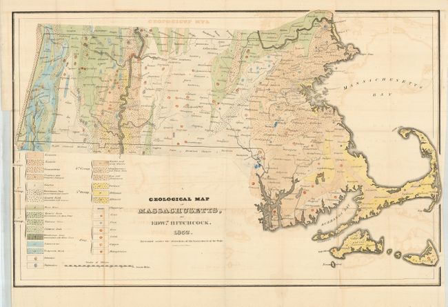
This 1832 issue is the first edition of Hitchcock's important map. This colorful map has an extensive legend with twenty geological formations shown through color and design, plus symbols to further locate deposits of plumbago, coal, peat, iron, lead, copper, and manganese. Hitchcock was an eminent professor of chemistry and natural history at Amherst College and was selected in 1830 to conduct a general survey of the Commonwealth of Massachusetts. He was the State Geologist 1830-33 and 1841-44. The publication of his first report and map in 1832 marked an epoch in American geological work as this was the first geological survey of an entire state conducted at public expense. It is also a fine example of early lithography by Pendleton's Lithogy., Boston. Hitchcock's maps were issued in small quantities and are seldom seen.
References: Schwartz & Ehrenberg pl.159; Marcou & Marcou No. 200; Phillips (M) p. 401.
Condition: B+
Issued folding now pressed and backed with archival tissue. With some light offsetting visible in blank areas, else very good.