Subject: Atlanta, Georgia - Civil War
Period: 1864 (dated)
Publication: Report of Chief Engineer U.S.A., 39th Congress, 1st Session
Color: Hand Color
Size:
21 x 12 inches
53.3 x 30.5 cm
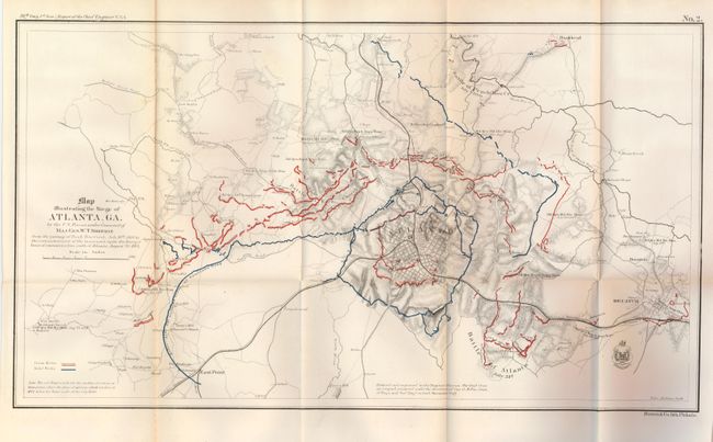
This fine Civil War map is dated 1864 but was published in the Chief Engineer's report of 1866. The title continues "from the passage of Peach Tree Creek, July 19th, 1864 to the commencement of the movement upon the Enemy's lines of communications south of Atlanta, August 26, 1864." The map extends to show the towns of East Point and Decatur and northward to Buckhead. Details the Union and Rebel positions in the Battle of Atlanta, the Battle of Peach Tree Creek, and the Battle of Ezra Creek in red and blue overprinting. Scores of small towns and villages, headquarters' of various armies, and much more are located. This is plate No. 2 from the report and is the earliest printed street level map of Atlanta. This early published map describes the intense military conflict to take Atlanta from the Confederacy.
References:
Condition: B+
One fold line with toning otherwise a clean, fine example. Folding as issued with great color, good impression and full margins.