Subject: California
Period: 1849 (dated)
Publication: Senate Doc. 47, 31st Congress, 1st Session
Color: Black & White
Size:
11 x 27.5 inches
27.9 x 69.9 cm
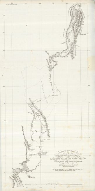
This map details the route of Warner's party from Benicia near San Francisco to Sacramento City, up the Sacramento River and into the High Sierras in the vicinity of Goose Lake. In the northern Sierras are "Mountains as far as the eye can reach." The Oregon Trail from the U.S. and the Oregon Trail from California is an early reference to the Oregon Trail, normally called the Immigrant Route at this time. Trails, farms, mines etc. are identified along the route. The map provides the first information of the mountainous region northeast of the Central Valley, and is a source document on the Lassen Cutoff.
Capt. Warner was tasked with finding a suitable railroad route up the Sacramento Valley. Though he discovered a suitable pass, his party was ambushed by Indians and he was killed (the location of his death is marked on the map). His notes and a sketch map were rescued, and from these Lt. Williamson produced this map and a report, the first published documents to show any detail of the country. A nice example of this map.
References: Wheat (TMW) #700; Wheat (Gold) #182.
Condition: B+
A very nice copy with clean paper and original margins. Originally folded now pressed. A few light foxing spots and a small stain in right margin.