Subject: Southwestern United States
Period: 1862 (dated)
Publication: HR Ex Doc No. 1, 37th Congress, 3rd Session
Color: Black & White
Size:
28.2 x 21 inches
71.6 x 53.3 cm
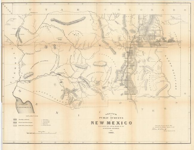
Early, large-scale, territorial map by the Surveyor Generals Office, Santa Fe, New Mexico. It includes all of today's Arizona and extends to show the northern reaches of the Sea of Cortez, California at the west and Colorado and Utah to the north. The area of present-day New Mexico is depicted with limited surveying, primarily the settled areas of Santa Fe, Albuquerque and down the valley of the Rio Grande River. Locates Dona Ana, El Paso and Ft. Bliss, Ft. Craig, Taos, the Hopi Pueblos, San Francisco Mountain, Ft. Buchanan, Ft. Yuma, Tucson, San Xavier, Tubac, and more. The center of the territory is noted as Unexplored. The area of today's Phoenix is Maricopa Wells. Most of Arizona is blank with little cartographic information save a few rudimentary rivers, two Indian Reservations, a few rivers and mountain ranges. Hachuring indicates those private and pueblo claims, and townships that have been surveyed. The next edition shows Arizona Territory. A most desirable map that is becoming increasingly difficult to find.
References:
Condition: B+
Issued folding, now pressed flat. Toned along most folds and some weakness along a few, still a handsome and sound example.