Subject: United States
Period: 1886 (dated)
Publication: American Institute of Mining Engineers International Geological Congress
Color: Printed Color
Size:
27.8 x 17.3 inches
70.6 x 43.9 cm
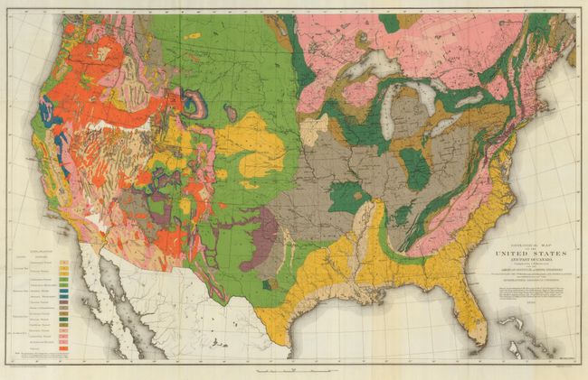
This edition of Hitchcock's important map is the first geological map of the entire United States. This claim was made by Hitchcock in the article, "The Geological Map of the United States" in volume XV, of the Transactions of the American Institute of Mining Engineers, 1886-1887, that originally accompanied the map. Hitchcock writes (p. 468): "For the first time in the history of American maps it has been possible to show the distribution of stratigraphical divisions of equal importance in every part of the country." Hitchcock describes the 1884 McGee U.S. Geological Survey national map as incomplete: "Because of the scarcity of existing and available information, it became necessary to leave the following States and Territories either partially or wholly uncolored: Arizona, California, Idaho, Montana, Nevada, New Mexico, Oregon, Texas, Utah, Washington." In the section listing the improvements in his (Hitchcock's) map, he notes: "2. Extension of the colors into the States and Territories of the far West," and he gives the sources for the new information that allowed him to fill in the western states.
This large chromolithographic map provides terrific detail of the geological formations of the country. An explanatory key to the colors indicates sixteen geological formations, increased from nine on the first edition of 1873. The carefully drawn map shows good geographical detail as well as remarkable geological information. Lithographed by Julius Bien on fine banknote-style paper, an edition we've not previously seen. An important and landmark geological map.
References:
Condition: A+
Folding, as issued. One paper crease in blank margin at lower left.