Subject: United States
Period: 1835 (circa)
Publication:
Color: Black & White
Size:
13.3 x 9.5 inches
33.8 x 24.1 cm
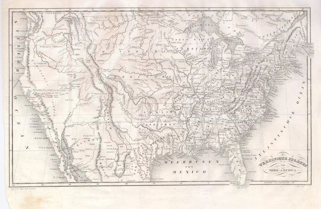
This interesting map of the United States places Texas in an area of Mexico labeled "San Luis de Potosi." Arkansas Territory includes the Indian Territory and part of Kansas. Missouri is shown as both a state and a separate territory, whose western boundary is unclear: it could to extend to the Rocky Mountains or even to the Pacific Ocean. The large Northwest Territory lies above Illinois. Michigan Territory is confined to the east of Lake Michigan. The West Coast is labeled Californien, Neu Californien, Neu Albion and Neu Caledonia, which is located east of Vancouver Island here called the Wakasch Nation. In California the missions or towns of St. Gabriel, St. Juan, St. Diego, St. Juan Baptista, Monterrey, St. Francisco and more are located. The Great Salt Lake has an indistinct western shoreline. Engraved by J. Locherer and printed by H. Bien of Basel. Most likely the work of Joseph Meyer.
References:
Condition: A
Unusual watermark is a signature in script. Full margins and fine impression. Folding as issued with binding trim at lower left.