Subject: World
Period: 1752 (dated)
Publication: Atlas Universel
Color: Hand Color
Size:
28 x 18.3 inches
71.1 x 46.5 cm
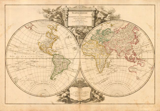
This is the first state of this lovely and decorative double-hemisphere map. The map shows the tracks of the voyages of Bouvet de Lozier (1738-9) in the Antarctic and of Anson (1740-43) across the Pacific, along with the Manilla - Acapulco route of the Spanish galleons. It was Anson's capture of a richly laden galleon in 1743 that made his expedition so important in the annals of Pacific voyages. Australia is composed of a partial western coastline and a conjectural coastline connected to Tasmania, Terre du S. Esprit and New Guinea. Terre de Diemen appears both in Tasmania and on the northern coast. In North America there is a note in the Pacific Northwest that the area is not well known. The map is decorated with an elaborate, figural cartouche that was designed by Cochin and engraved by Tardieu. The attribution cartouche at the bottom is flanked by putti and clouds.
References: Pedley #8.
Condition: B
Original outline color on the map with some foxing and stains. There is a centerfold separation about halfway into the map, closed with an old linen repair on the verso. The cartouche has an abraded area with some paper adhered to a small portion of it, with some loss of the smaller letters. Overall the map is still very attractive.