Subject: California
Period: 1849-95
Publication:
Color: Black & White
Size:
16.8 x 23.5 inches
42.7 x 59.7 cm
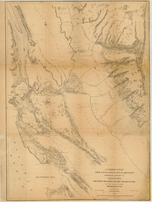
1) A Correct Map from Actual Surveys… by Charles Wilkes from Western America, including California and Oregon…, 1849. This important and scarce Gold Rush map shows the valley of the Sacramento River, extending to the San Francisco and Monterey Bays. It provides one of the earliest detailed topographical accounts of the San Francisco Bay and Gold Regions in California. This map was drawn by F. D. Stuart, and entered into Congress by Lea & Blanchard. The topography and geological features are meticulously noted on this map, including plentiful oak groves, alluvial deposits and locations of water. Roads are located running from San Francisco to Monterey, and the pueblo of San Jose is noted. The map locates New Helvetia on the banks of the American River, the large 'fort' and farm founded in 1839 by Swiss pioneer John Sutter, later known as Sutter's Mill, where gold was found in 1848. The hordes of gold seekers overran the farm in 1849, ruining his crops and butchering his livestock. Sutter went bankrupt, and unsuccessfully attempted to get the U.S. government to reimburse him for his losses. His son, John Sutter, Jr., went on to found the city of Sacramento, the first officially recognized city within the new state ). The largest of three maps (16.8 x 23.5") in Wilkes' book on the West, it is rarely found in very good condition. This example is toned and backed with tissue to support splits and weakness at fold intersections. With some paper replacement on some folds and in bottom corners with neat facsimile of missing image. Grade B.
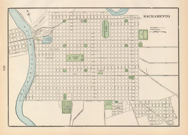
2) Sacramento, by George Cram, circa 1895. This is a fine plan of the still small capital city showing the grid of streets with both existing and proposed railways. The map covers from east of the drainage canal in the south to North Street, and from a bit west of the Sacramento River to east of 31st Street. The rivers, parks and cemeteries are designated with printed color (13 x 9"). Grade A+.
References: 1) Wheat (TMW) # 646; Wheat (Gold) #134; Howes W416.
Condition:
See description.